
Recent lidar flights over the Eaton and Palisades burn areas have provided valuable data following the wildfires that were contained in late January 2025. Sponsored by ALERTCalifornia and conducted by the engineering firm NV5, these lidar scans have now been made publicly accessible through the US Geological Survey.
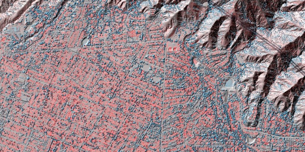
Cassandra Brigham and her team from Arizona State University compared lidar data from 2016 with information gathered in January 2025. This analysis allowed them to visualize changes in elevation, indicating the loss of buildings, trees, and other structures. To produce timely results, Brigham’s team refined and updated older data before comparing it with the new data, resulting in visualizations that illustrate the extent of the destruction, which surpass the insights provided by satellite images. The visualizations employ a color-coded system, with red indicating a loss in elevation and blue representing gains such as tree growth or new construction.
Lidar technology is increasingly being utilized to assess the aftermath of climate-related disasters. In instances like the Eaton and Palisades fires, where extensive vegetation was burned, subsequent heavy rainfall can lead to debris flows, mudslides, and landslides. This ability to quantify the impact of such events can inform preparedness for future natural disasters, including fires and floods.
However, the future of these important lidar data collection initiatives may be at risk as policymakers contemplate budget cuts to scientific research. The ongoing investment in such technologies is critical for understanding and mitigating the effects of climate-driven challenges.
Source: https://www.technologyreview.com/2025/08/25/1121450/lidar-climate-change-disasters-cost/